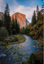
I took this in May of 2010 down in Cleghorn Canyon near Silverwood Lake. It's down around the 3,000 foot level on the 'backside,' or north-facing slopes. At this low level of elevation there's a lot of sagebrush and scrub but it's still a pretty area with a nice creek that flows into Silverwood Lake. Silverwood isn't a natural lake, but a huge state reservoir.
This is a very small part of Lake Silverwood. There used to be pines and cedars, but a lot of them burned in the huge fire of 2003, and more were lost to the pine bark beetle invasion. They're starting to come back, but very, very slowly.
The Pacific Crest Trail passes near here. The trail runs from the border of Mexico to the border of Canada through three states; California, Oregon and Washington and is 2,654 miles long.
I don't know why some people are compelled to shoot at signs...
And, I don't know why this huge, precariously balanced boulder that's on the hill above the sign hasn't fallen on someone!
It's probably a whole lot more stable than it looks, but I wasn't about to climb up there and check...


Victoria - magnificent pictures and as for that boulder I am not certain why it is still there either. Thanks for sharing. Hope you have a great week.
ReplyDeleteGorgeous sunset! And, even reservoirs can look so beautiful, in the right setting.
ReplyDeleteThe Pacific Crest Trail sounds amazing! Is it for hikers and horse riders and mountain bikers mostly?
And that huge rock - nature's incredible balance :)
Glad you liked them, Debbie, thanks!
ReplyDeleteVicki, the PCT is only for hikers and equestrians. I don't know if mountain bikes are allowed; they only mention hiking and horses on the website and they have a very strict 'leave no trace' policy. I'm glad you liked the sunset, thanks!